 |
| Source: Weather Undergroundlink |
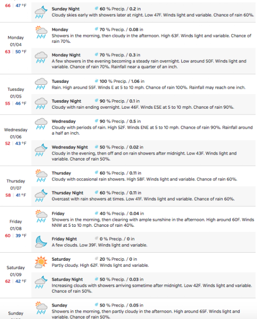
A series of storms to affect southwestern California much of next week... Time to prepare for potential flooding and debris flows from recent burn areas... A series of storm systems are lining up across the Pacific Ocean and will affect much of the forecast area through next week. Southwestern California can expect between 2 to 3.5 inches of rain across coast and valleys through Friday... and between 3 to 5 inches across the mountains. Locally to 6 inches across favored SW facing coastal slopes including the Santa Ynez and San Gabriel Mountains.
This much rain in a short period of time could bring flooding and debris flows from recent burn areas. The first storm which arrives Sunday afternoon or evening will bring some periods of heavy rain across Los Angeles and Ventura counties... with less intensity to the north. However... a more significant storm will be right on its heelsTuesday morning. This system will tap into a more subtropical air mass allowing for higher rainfall rates and rainfall totals. Tuesday through Tuesday evening will be the time period where the potential for flash flooding from debris flows will be high.
There will be a brief lull between storms Tuesday night into Wednesday morning... when another significant storm moves into the region. Once again... expect periods of heavy rain through Wednesday night where additional flooding is possible. Rain will taper off to showers by Thursday... but there will be enough cold air associated with the upper low that some thunderstorms will be possible.
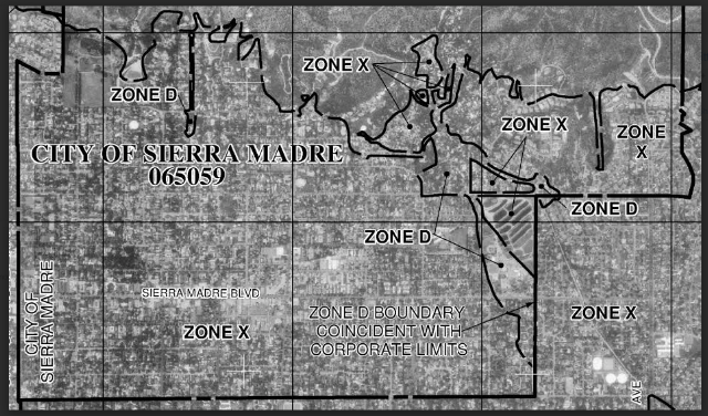
Pretty impressive. Below is the FEMA flood map for Sierra Madre, with a decoder for whatever is on there just below that.


Time to crack out the umbrella and galoshes.
sierramadretattler.blogspot.com